Easier to reach than expected, but stranger, too.
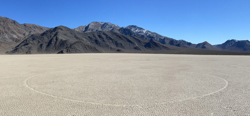
For years, my wife and I have wanted to visit the Racetrack in Death Valley National Park. It’s a smaller closed drainage basin, a playa, northwest of Death Valley (DV) itself. While it’s quite beautiful, it’s famous for the mysterious rocks on the playa surface with tracks showing the rocks have moved. Even stranger are the tracks without rocks. At first we thought someone had taken the rocks. The almost perfect circle in the featured image above was a long walk from the west edge where the road is and most visitors hang out, yet had no rock. This article uses a number of high resolution images, so it may take awhile to load all of them. Except for the featured images, they are the originals in my Google Photos album of the trip, so can be viewed at full resolution.

More typical were tracks with rocks like this striking set of six, just east of the rocky outcrop called The Grandstand, which is a short distance from the parking area at the northwest corner of the playa.
The Park Service has dire warnings about traveling to the Racetrack on a dirt road described as covered by tire-eating sharp rocks. They strongly recommend high clearance 4×4 type vehicles. Although we had been traveling to DV for decades, we didn’t think about going to the Racetrack until after my 1991 Isuzu Trooper 4×4 died of old age at 200,000+ miles. We were quite willing to take its successors, a Toyota Echo then 3 Prii on some of the back roads in DV, but that one sounded beyond the pale. The photo below is at Aguereberry Camp on our way out to Aguereberry Point in 2010 on the dirt roads in the Panamint Range upland on the west side of the valley. The white speck is a 2009 Prius.

In 2020, we realized we needed something with ground clearance so we could take our now 4 1/2 year old grandson on more adventures. We had been using my wife’s Toyota Tacoma truck on rougher roads, but it only has two seats. We exchanged a 2017 Prius for a new 2020 RAV4 Hybrid. While it only gets ~45 mpg around town, it can go lots of places we were unwilling to take a Prius, like the Control Road down the back side of Mt. Lemmon. Our grandson loved that trip.
To make the RAV4 a better field vehicle, I got a full-sized spare to replace the inadequate doughnut that it came with after I learned the wheel well was large enough for a full-sized wheel and tire. I kept the doughnut, which we store in the garage when we’re not on trips. I also added a trailer hitch receiver for a hitch mount bike rack. Both were supplied and installed by the Toyota dealer that services our vehicles. When the pandemic settled down some in 2021, and the grandson was out of town on a trip with his parents, we took the RAV4 on its first DV trip. Complications arose when a tire started to show low air on the outskirts of Phoenix. Because we had a full sized spare, plus the doughnut, I just changed to the full-sized spare. We continued our trip, rather than limp to a tire shop on the doughnut. That did limit our willingness to try out the RAV4 on back roads.
I normally hang out with our grandson almost every day. When the grandson and his parents decided to go to Colorado to snowboard at the end of February 2022, I booked us rooms in DV again. This time I hoped that if we had all our tires combined with cool winter weather, that a trip to the Racetrack might be practical. A quick search revealed the Earth Trekkers’ account of their visit. I glanced at the pictures and saw a Ford Explorer with about the same ground clearance as the RAV4 (8 inches), and what looked like an easily traversable dirt road.
We drove to DV on Thursday February 24th, keeping air in all tires. I filled the RV4’s 14.5 gallon gas tank the night before. I reset the MPG display to track our actual trip mileage. As with all hybrids, the RAV4’s mileage is best in stop and go traffic at low to moderate speeds when the computer can switch off the gasoline engine as much as possible. It drops significantly at steady Interstate speeds, 37.9 mpg for this trip. While we could have gotten to Pahrump before filling up, we decided to stop along Blue Diamond Road as we skirted the south edge of Las Vegas. With the Prii, which had 10-11 gallon tanks, we could often avoid buying the expensive Furnace Creek gas station fuel on our shorter visits to DV. We had found on the August 2021 trip we could do the same with the RAV4, which actually has a longer range with the larger gas tank. We got there before dark and managed to swap our reserved Casita (newly built, more expensive, no Internet yet, no views to speak of) for a motel room, thanks to a helpful front desk person. We had an expensive, but tasty meal at the Last Kind Words Saloon, then went to bed. We slept in and didn’t get organized for our expedition until 9:30 or so.
We had both our full-sized spare and our doughnut. I had assembled two bins of tools, emergency gear, and water. We selected some food and clothing to take in case we got stuck somewhere. Then we went to the Furnace Creek Gas Station and topped off our tank with $7+ gasoline (As I write this, it’s up to $8.99 according to Gas Buddy). We continued to the Furnace Creek Visitor’s Center to show our lifetime senior park pass and ask about conditions out to the Racetrack. The ranger wanted to know if we had all-terrain tires. I don’t know, so I said yes. I knew they were similar to the Tacoma tires and in good condition. Since then I’ve checked and found it has Firestone Destination LE 2 light truck and SUV highway tires– no surprise. I told him we had two spares, one full-sized, which satisfied him. He said the road was open, blessed our trip, and thought it sounded nifty.
From Furnace Creek Ranch, we drove 56 miles to Ubehebe Crater on good paved roads that we know well. We have explored that complex of craters several times before. We reached the turnoff, with its warning sign “High Clearance 4×4 Recommended.” I’ve driven an array of vehicles, including the aforementioned Trooper, on an array of roads. Even so, based on the dire warnings, I admit to some caution as we turned onto the dirt road just below the Ubehebe lookout. What we found was actually a fairly nice, well-graded road with rocks that looked like every other rock we’ve seen on back roads around DV. On some straight smoother stretches I got up to 40 mph. There was one very short (~100 yards) up and down section around a silty, churned up spot that had obviously been pretty muddy when wet. The detour was no problem for the RAV4. The main concern should be the remoteness of the route with no cell service. It would unwise to attempt the drive with only a doughnut spare, which are only rated for short distances, especially on poor quality roads. There were a number of other vehicles on the road and at the playa, mostly jeeps, 4×4 trucks, and similar heavy duty off-road things. There was a Subaru SUV at the parking area, and a Honda Element passed going out as we headed in. On the way out we saw what sure looked like a large Amazon delivery van (with Amazon painted on the side) parked just east of Tea Kettle Junction on the Hunter Mountain Road. No one seemed to be having any difficulties with the road conditions.


The road climbs from just over 2500 feet elevation to 4953, then drops down to the Racetrack Playa, which is about 3708. It is one of the more scenic drives we’ve done in DV National Park, made even more so by the snow on many slopes and peaks. We passed through a zone of multi-headed barrel cacti, then stands of scraggly Joshua trees higher up. Here’s a track of the drive out I made at home later with Scott Morris’ TopoFusion mapping software on a USGS topographical map background.

Both the RAV4’s odometer and this track show the distance is significantly less than 27 miles claimed in some descriptions. It’s a bit over 25. When I overlaid the track I traced using the topo map road onto Google satellite photos, the match was very good. Later I saw the Park Service is now saying 26.
We parked at the first parking area next to the northwest edge of the playa, opposite the Grandstand. Over a dozen vehicles were there, although most were part of a convoy that soon left headed south.

We assembled our clothing layers and hiking gear, then headed out. My wife also brought her high-end digital camera and a tripod. The Grandstand is only a quarter mile from the parking area. Looking back from there, we could see Ubehebe Peak. The specks on the playa edge to the right are our RAV4 and another vehicle.

According to the RAV4, it was about 47 degrees when we started out near midday. It’s usually a couple of degrees high. The prevailing wind from the south was cold. On the east side of The Grandstand there was still some snow, the first we have seen up close on a winter visit to DV National Park.

From the Grandstand, we headed SSE toward the rugged edge of the playa, well away from the west flank where the road and the second parking area are. Here’s a look back north at the Grandstand.

We soon came across a break in the mud cobblestone surface, a line of vegetation. According to the Wikipedia article on the Racetrack, this is Spinal Spring, which runs for 550 meters. I don’t want to pay for the article cited there and can’t find any other reference to the Spinal and the two other springs, but we’re interested in going back to trace Spinal and find the other two.


We continued across the playa, encountering the occasional rock, some with tracks, some not. We also encountered tracks without rocks, which was a surprise given how far we where from the west edge where the people hang out. At this point we were still thinking the rocks had been appropriated.


The south edge of the playa was getting closer after considerable walking. Those are the Cottonwood Mountains, the northern section of the Panamint Range.

My wife had stopped to set up her tripod and take photos, so I kept trudging in the same direction we had been going. She caught up later. Eventually, I reached the playa edge.

There were lots of rocks and lots of tracks. Below is one of the longer tracks made by a bigger rock.


After a bit of wandering to examine rocks and tracks, we headed back north across the playa, on a line a bit west of our line south. Rocks and tracks were seen along the way. The most interesting track was the almost perfect circle I showed at the top of the article. Here’s our trek.

We were on the playa for 2 hours and 35 minutes, traveling 5.7 miles. Once back, we put our gear away, then started north. Here are some photos along the way. All except the multi-headed barrel photos were taken on the way out, when we were more willing to stop and look around.


Even with stops, we may have driven out faster than we went in because I was more confident of road conditions. Once we picked up the paved road at Ubehebe Crater, it was an hour or less to Furnace Creek. We had another pleasant, albeit expensive dinner at The Last Kind Words Saloon.
The next day, we went a short distance south on the unpaved West Side Road in Death Valley itself to a road my wife found on the maps that she wanted us to drive up a bit, then walk into the mouth of one of the big canyons coming off the Panamint Range. That road was significantly nastier than the one the day previous. Here’s a photo of Death Valley from that trek.

The pale area above my wife’s head, slightly to the right, is Badwater Basin itself, as larger or larger than Racetrack Playa. Death Valley’s below-sea-level floor extends beyond the photo in both directions. Those are the mountains of the Amargosa Range in the background. Clearly, DV is on a different scale than the Racetrack.
I didn’t read the Park Service’s page on the Racetrack until after we came home. Once past the dire warnings, the page had a pretty interesting description of the work by Richard Norris, James Norris, and others that has solved much of the mystery regarding how the rocks more. They wired up rocks for remote monitoring, but Richard and James were actually lucky enough to visit the playa when a move event occurred. In brief, there needed to be enough rain in the winter to cause a layer of water on the playa. Then a freeze was needed. When it started to warm and the sheets of ice started to break up and move in surprisingly light winds, the rocks embedded in those sheets moved as well across the very slippery wet mud surface of the playa. The sheets of ice could also leave tracks, which explained the tracks we found with no rocks.
We want to go back to the Racetrack. Rocks or not, it’s a fascinating part of Death Valley National Park. It’s 3990 feet higher than Badwater Basin, which suggests it is practical to visit in the summer if one is prepared and careful. Google searches claim it typically only gets a bit over 100, which is not bad for someone from Tucson. The hike to Ubehebe Peak looks interesting. My wife talked about a run around the perimeter. For that matter, she noticed the road to the Racetrack was a bit shy of the marathon distance. There are springs to find and trace. There’s more to explore further south. I am mystified by the concerns about the road into the Racetrack, but in fairness I am experienced with poor backroads in the American Southwest. One should still be careful, as many people have come to grief in Death Valley and its environs.